

Published : 07 Oct 2026, 02:22 AM
Updated : 07 Oct 2026, 02:36 AM


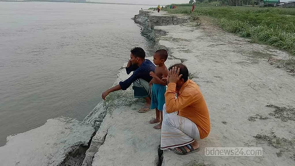
For Abdul Momin, the river did not take his home all at once. It took the ground beneath it piece by piece, until the house he had built with a lifetime of savings was gone.
“This char was where my father and grandfather had their homestead. I built a house here with all my life's savings. Within a few days, everything was gone into the river. Now I am living temporarily on someone else's land.”
Momin lost his homestead to the Jamuna's relentless erosion. His story is repeated along Bangladesh's great rivers, where the landscape can change in a matter of days and generations of family history can disappear beneath brown, shifting water.
Another resident, Rafiqul Islam, watched his home vanish.
“Everything disappeared into the river before our eyes. Now I am deeply worried about where we will go and what we will eat with our families.”
About 20km from Kazipur Upazila headquarters in Sirajganj, through a winding route of river channels and chars, lies Chargirish. The settlement has already lost homes, land and the graves of its dead.
“Our ancestors' graves and mosque have gone into the river,” said local resident Zahurul Islam. “The pain of losing the graves of our own people is beyond words.”
Al Amin Sarker, a member of Chargirish union council, fears more than 100 families could lose their homes as the Jamuna continues to eat into the sandbar.
Some 500 to 600 families once lived there. About 150 have already moved elsewhere because of erosion. In June alone, at least 30 families became homeless within 10 days.
The scale of what has happened across the country's three major rivers is staggering.
According to the Centre for Environmental and Geographic Information Services (CEGIS), a public-interest trust under the Ministry of Water Resources, 94,150 hectares of land disappeared into the Jamuna between 1973 and 2026.
Erosion along the Ganges claimed 30,482 hectares and along the Padma 33,885 hectares during the same period.
Together, the three rivers swallowed 158,517 hectares, or 1,585.17 sqkm, in 53 years -- an area larger than Dhaka district and roughly five times the combined area of Dhaka's two city corporations.
Yet the story is not simply one of disappearance.
The same rivers have also created about 43,259 hectares, or 432.59 sqkm, of new land in the form of sandbar.
That apparent contradiction -- land vanishing in one place while it rises somewhere else -- is the defining rhythm of Bangladesh's riverine landscape.
Where the River Takes, the River Gives
CEGIS's satellite-image analysis shows that the Jamuna has experienced the most extensive erosion.
Between 1973 and 2026, its banks lost 94,150 hectares while 14,955 hectares of new sandbars emerged.
Erosion was particularly severe across the Jamuna basin, affecting Bogura, Gaibandha, Jamalpur, Kurigram, Manikganj, Pabna, Sirajganj and Tangail.
In the Ganges basin, covering parts of Kushtia, Natore, Chapainawabganj, Pabna, Rajbari and Rajshahi, 30,482 hectares disappeared while 23,192 hectares emerged. Kushtia was the hardest hit, with 11,758 hectares lost.
CEGIS says the balance between erosion and deposition has kept the Ganges' overall width relatively stable.
The river is known as the Padma after entering Bangladesh, but water-resource experts classify the stretch from near Chapainawabganj to its confluence with the Jamuna as the Ganges for technical and engineering purposes because of differences in flow characteristics.
From the Jamuna-Ganges confluence at Goalanda in Rajbari to the Meghna estuary at Chandpur, it is identified as the Padma.
Along the Padma, 33,885 hectares disappeared over the five decades while 5,112 hectares emerged. Up to 2025, Shariatpur suffered the most erosion among the districts along the river, losing 9,011 hectares.
But the pace of erosion has changed.
Experts say that while roughly 9,500 hectares disappeared annually in the 1990s, erosion along the three major rivers has now fallen to around 1,000 to 1,500 hectares a year.
Sudipta Kumar Hore, a senior specialist at CEGIS's River, Delta and Coastal Morphology Division, attributes the decline to both nature and human intervention.
“Overall, the number of vulnerable locations has decreased, and the amount of erosion is also declining. Over time, effective measures have been taken along both banks of the rivers, and the Water Development Board has undertaken river-protection works. The combination of these two factors means that erosion along the three major rivers has now reduced considerably.”
He said the rivers themselves were also changing.
“We have seen that many places where erosion used to occur are no longer eroding. Again, when a river naturally begins to stabilise gradually, it has a young phase, when its energy is much greater; that means the amount of erosion is also much higher.
“Two things are happening at the same time -- the rivers are gradually moving from a young to a mature stage, while protection works are also being carried out.”
CEGIS, Sudipta said, studies the emergence of chars alongside erosion.
What Disappears Cannot Simply Be Replaced
The emergence of 43,259 hectares of new land might appear to offset some of what has been lost. But experts caution against treating the two figures as equivalent.
Malik Fida Abdullah Khan, a former executive director of CEGIS, said erosion and accretion were fundamentally different processes.
“If we do not look at the whole picture and simply say that this much land has disappeared from our rivers, that is not enough; the two cannot be fully compared.
“When erosion occurs, a fully developed piece of land is lost. When a char emerges, everything there is new. So the two cannot be compared.”
A mature piece of land may take a century to develop, he said.
“It takes a hundred years to develop a piece of land. So a mature piece of land and a new char that has emerged in an estuary are not the same. But it must also be said that sedimentation is creating new chars there.”
He pointed to Bhasan Char, Char Nangolia and Urirchar as examples of land formed through sediment deposited downstream.
“The erosion that has taken place has been accompanied by accretion and deposition. Some of the sediment goes into the estuary and creates new chars. This Bhasan Char has been formed from that sediment.
“The sediment is deposited there. This is how developments such as Char Nangolia and Urirchar have emerged. The sediment flows through the Meghna into the estuary, where it is deposited and gradually develops these chars.”
The challenge, Malik said, is to manage the entire system rather than focusing only on erosion.
“We need an overall plan. We need to know how much erosion is taking place, how much accretion is occurring, how much is happening in the river and how much in the estuary, and then plan around how much of it we can retain.
“The amount of land that can now be reclaimed in the estuary must be acted upon immediately. Otherwise, this land may be eroded again. We have to keep that in mind and look at the entire system as a whole.”
Predicting Where the River Will Strike
CEGIS has been forecasting erosion along the Ganges, Padma and Jamuna since 2004.
Using satellite imagery and statistical modelling, it identifies areas with a 70 percent, 50 percent or 30 percent probability of erosion, classifying them as high, medium or low risk.
The forecasts cover not only land but also settlements, roads, educational institutions, health centres and other infrastructure.
“Specifically, we work on three major rivers -- the Padma, Ganges and Jamuna. Among these three, the Jamuna is now largely protected,” said CEGIS Principal Specialist ATM Kamal Hossain.
“Erosion is now much lower than before. It used to occur in many places; now it occurs in far fewer.”
CEGIS has issued annual forecasts since 2004. Kamal said the Bangladesh Water Development Board was its biggest stakeholder and government agencies used its reports.
The current forecasts cover one year, but CEGIS plans to develop two-year forecasts.
The work is also expanding. CEGIS and the Water Development Board are now studying 12 medium-sized rivers, including the Teesta, Dudhkumar, Atrai, Ichamati, Gorai, Kirtankhola, Arial Khan, Pungli, Kaliganga, Dhaleshwari, Sangu and Jadukata-Rakti.
Malik Fida Khan said more testing was needed before reliable forecasts could be developed for such rivers.
“Building such an equation or system for rivers like those in Bangladesh requires a lot of experimentation. Once that validation has been carried out for several years, we hope it will be possible to provide erosion forecasts successfully for these medium-sized rivers.”
Kamal said the effort could eventually cover more rivers.
“The Jamuna, Ganges and Padma are large rivers; we are working on some medium-sized rivers and, God willing, we will succeed. This is part of a research project.
“Since erosion in the three major rivers is gradually declining, we are working to develop a tool for forecasting erosion on more medium-sized rivers. Perhaps in the coming years we will be able to provide forecasts for many more rivers.”
Forecasts can give communities time to protect farmland, crops and movable assets and allow authorities to plan river-protection works before disaster strikes.
In 2007, experimental forecasts were delivered to communities in four locations along the Jamuna and Padma. Residents used the information to protect their belongings. UNDP, BRAC and CARE Bangladesh later helped distribute forecasts to riverbank communities.
Areas already protected by river-management or bank-protection structures are generally excluded from the forecasting programme.
Kamal explained why.
“First, we forecast where there are protection works. Then we identify where there are no protection works and where the risks are.
“If the government plans to build a structure in one of those vulnerable areas, we advise against it. If they follow the report, their investment will not be wasted. Or, if someone has movable assets, they can learn about the forecast and move them -- at least they can save some of their assets.”
The Next Wave
CEGIS's 2025 forecasts broadly matched what happened on the ground.
Of five locations identified along the Jamuna, four experienced erosion. Two other locations suffered erosion despite not being forecast.
On the Padma, erosion occurred at every forecast location. The Ganges forecasts also matched the actual erosion at all identified sites, although two additional locations experienced unpredicted erosion.
In 2025, 348 hectares of land and 70 hectares of settlements disappeared in the Jamuna basin, while the Ganges lost 593 hectares of land and 24 hectares of settlements. The Padma lost 93 hectares of land and 9 hectares of settlements.
Altogether, 1,137 hectares disappeared.
This year's forecast identifies 11 vulnerable areas across eight districts: seven along the Jamuna, three along the Ganges and one along the Padma. At least half of the vulnerable areas on both banks of the Jamuna are forecast to disappear.
The Jamuna risk zones include Kurigram Sadar; two locations in Sundarganj and one in Phulchhari in Gaibandha; Roumari in Kurigram; Dewanganj in Jamalpur; and Kazipur in Sirajganj.
The Ganges zones include Daulatpur in Kushtia, Sujanagar in Pabna and areas covering Ishwardi, Pabna Sadar and Kushtia Sadar.
The Padma risk zone is in Faridpur’s Sadarpur.
CEGIS estimates that 988 hectares of land and settlements could be lost this year. That includes 460 hectares of land and 64 hectares of settlements along the Jamuna, 320 hectares of land and 5 hectares of settlements in the Ganges basin, and 135 hectares of land and four hectares of settlements along the Padma.
The threatened areas include two government primary schools in Gaibandha, two mosques in Kurigram, a mosque and community clinic in Jamalpur, and a high school in Kushtia.
The worst may come after the monsoon.
“As the monsoon season is almost over, the water will now recede, so the amount of erosion will increase,” Hor said. “When the water first arrives, there is a strong current and erosion also occurs then.
“Another thing people do not understand is that in July and August the rivers are full. But when the water begins to fall, it recedes quickly. As the water drains from inside the soil, voids are created and the soil's internal bonding capacity changes. As a result, erosion is comparatively greater as the water recedes.”
Prof AKM Saiful Islam of BUET's Institute of Water and Flood Management also said erosion tends to intensify after the monsoon.
“When the water rises during the monsoon, the soil and riverbanks become saturated and remain soft. When the water level falls, the water from above moves downwards -- this is called seepage -- and the banks become fragile.”
There are about 1,415 rivers in Bangladesh. Around 30 percent have year-round flow, while most of the others carry substantial water during the monsoon.
Bangladesh has embankments stretching about 7,000km, but Saiful said many are old, poorly compacted or structurally weak.
“Large rivers have extremely strong currents and carry a lot of sediment. It is not all the fault of construction. Containing rivers of this size is itself a challenge, especially the Brahmaputra, Padma, Teesta and Meghna. At the same time, we have not always completed work on time or even started it when we should have, and there are budgetary and economic constraints. That is a challenge for Bangladesh.”
Permanent solutions such as blocks and geobags can be costly, while temporary measures include sandbags and groynes.
Fida Khan said the major rivers were unlikely ever to reach zero erosion.
“Overall, the amount of erosion in the three rivers has decreased; it is never possible to bring erosion down to zero. We are a deltaic country -- we have to understand that. Given our soil structure, the way the delta is formed and the quality of the sediment, all these factors mean that it is not possible to bring it down to zero.
“Many parts of the major rivers have now been brought to a tolerable level. We have to work on medium-sized rivers, where erosion remains more severe. A little erosion there can leave many families landless and homeless.”
Bangladesh receives about one billion tonnes of sediment a year from its three major rivers, Fida Khan said. The task now is to understand where that sediment goes, balance erosion against deposition and recover land where possible.
“The initiative is needed now so that we can restore these areas and increase the amount of land.”
The rivers will keep moving. Banks will collapse, channels will shift and chars will rise from the same sediment that destroys homes elsewhere. For communities like Chargirish, that geological rhythm is not an abstraction. It is the loss of a home, a mosque, a graveyard and a future.
The challenge for Bangladesh is no longer simply to stop the rivers. It is to understand their movement well enough to protect people from its most destructive turns -- while making the most of the new land the rivers leave behind.