Published : 14 Nov 2013, 01:44 AM
Updated : 09 Aug 2022, 11:19 AM


Its latest report, “Provisional Statement on Status of Climate in 2013’ was released on Wednesday to inform negotiators at the ongoing United Nations Climate Change Conference in Warsaw, Poland.
The year 2013 is currently on course to be among the top ten warmest years since modern records began in 1850, according to the World Meteorological Organisation.
The first nine months, January to September, tied with 2003 as the seventh warmest such period on record, with a global land and ocean surface temperature of about 0.48 C (0.86 F) above the 1961-1990 average.
WMO provides a snapshot of regional and national temperatures in this report. It also includes details on precipitation, floods, droughts, tropical cyclones, ice cover and sea-level.
January-September 2013 was warmer than the same period in both 2011 and 2012, when La Niña had a cooling influence.
Neither La Niña nor El Niño conditions were present during the first nine months of 2013 and are not expected to emerge by the end of the year.
El Niño/La Niña is a major driver of our climate and the hottest years on record, 2010 and 1998, both had El Niño events.
In contrast with 2012, when the United States, in particular, observed record high annual temperatures, the warmth in 2013 was most extreme in Australia.
“Temperatures so far this year are about the same as the average during 2001-2010, which was the warmest decade on record,” said WMO Secretary-General Michel Jarraud in a statement.
“All of the warmest years have been since 1998 and this year once again continues the underlying, long-term trend The coldest years now are warmer than the hottest years before 1998,” he said.
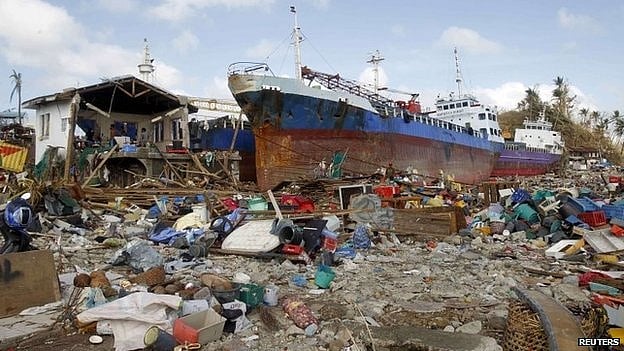
Speaking to journalists, Jerry Lengoasa, deputy secretary general of the WMO, said: “Sea level rise was particularly significant in the Pacific around the Philippines and had contributed greatly to the devastation caused by the super-typhoon Haiyan.
“The population should have been warned about the tsunami effect of a seven-metre storm surge caused by the typhoon,” he said, “so that they could have been better prepared to retreat to higher ground.”
Acoording the WMO statistics, there had already been 30 named storms in the Pacific this year; this was above the average of the last three decades.
Lengoasa said: “What the science tells us is not that there will be more storms, but that the storms we do have will be more violent.
“‘Perfect storms’, if we can call them that, like hurricane Sandy last year and typhoon Haiyan this year will become the normal.”
Sea level had risen a third of a metre in the central Philippines area since 1901, making the area much more vulnerable to storm surges.
The average sea level rise round the globe was much lower but was speeding up, and was now 3.2 millimetres a year. This is double the annual average of the last century - 1.6 mm.
Lengoasa made special mention of the unprecedented heatwave in Australia, which had the hottest month ever observed in January 2013, and the hottest summer on record.
On Jan 7, a new national average daily maximum for Australia was set at 40.3°C, and Moomba in South Australia reached 49.6°C.
Bill Hare, director of Climate Analytics, said: “The existing legislation would have bent the relentless upward curve of Australian emissions downwards, a first step towards a low carbon, climate-safe future.
“The new policy will see this dismantled and replaced by a climate policy that goes against the science.”
An Australian climate campaigner for Climate Action Network, Julie-Anne Richards, said her country was the new pariah in climate action.
“Even the United States and China take more action in fighting climate change than Australia”, she said.
Lengoasa’s presentation was a summary of the weather statistics up to the end of September this year.
According to the WMO report, the year had also been notable for regional floods and droughts.