


Published : 28 Aug 2026, 04:38 PM
Updated : 08 Sep 2026, 09:36 AM


The flood was already racing through Nepal by the time the warning system knew it was coming.
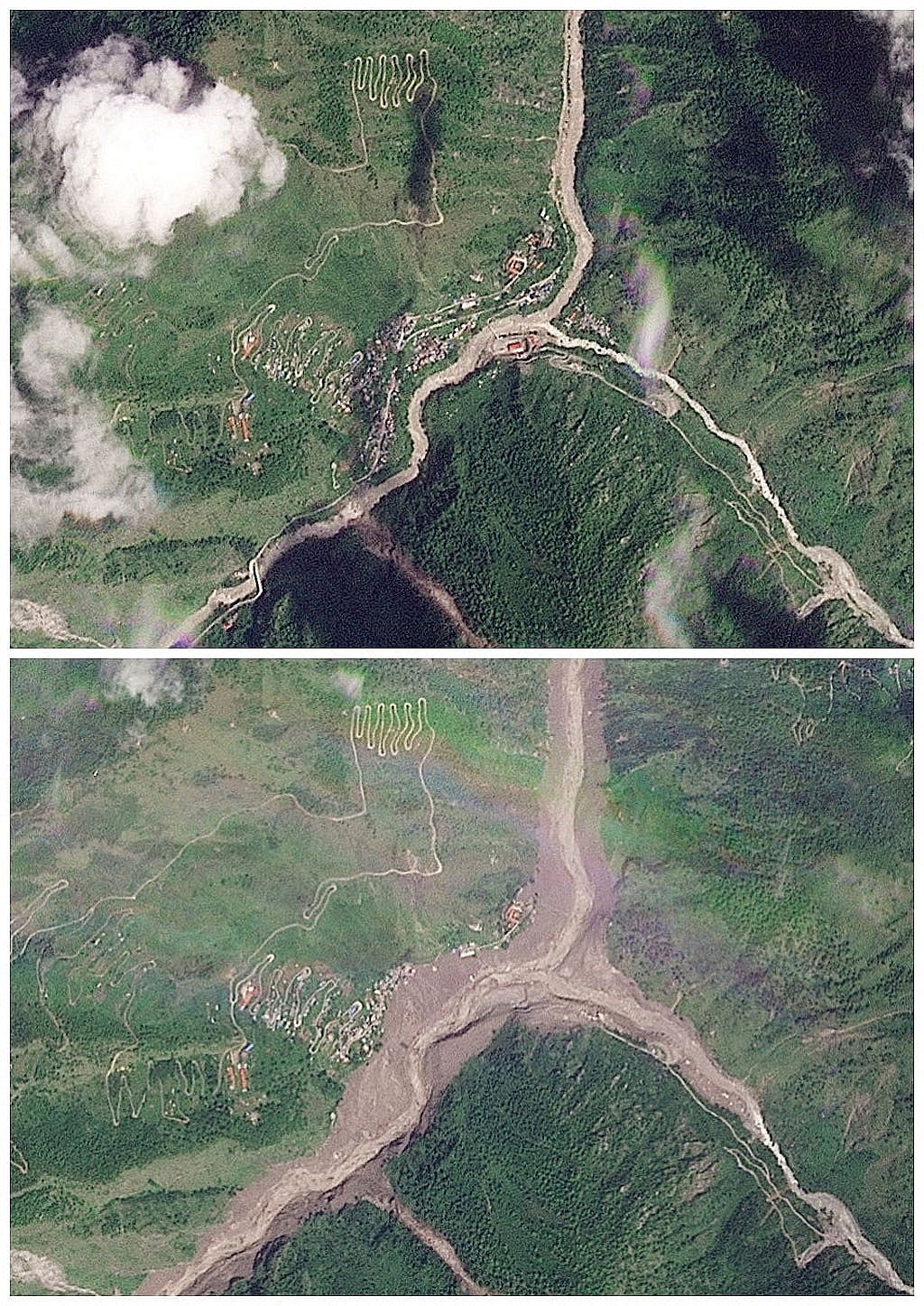
When the catastrophic surge crossed the Nepal-China border at Rasuwagadhi around 8:40am on Wednesday, authorities in Kathmandu had received no advance warning of the approaching wall of water, according to local news portal Nepal News.
Within about 10 minutes, it had reached Syabrubesi, roughly 14km downstream.
Nepal’s Department of Hydrology and Meteorology received its first information about the flood at 8:56am — around 16 minutes after it had entered the country — and sent SMS alerts to downstream communities before 9am.
By then, however, the flood was already tearing through upper Rasuwa.
The extraordinary speed of the disaster, combined with the apparent collapse of a glacier high in the mountains and gaps in cross-border warning, has exposed the limitations of Nepal’s existing flood-monitoring system.
So what went wrong — and could people have been warned earlier?
When Did Nepal Know the Flood Was Coming?
Not until after it had crossed the border.
Nepal News reports that information reached the Department of Hydrology and Meteorology through the Rasuwa district administration and the National Disaster Risk Reduction and Management Authority at about 8:56am.
Senior hydrologist Binod Parajuli said SMS alerts were issued to downstream communities within minutes.
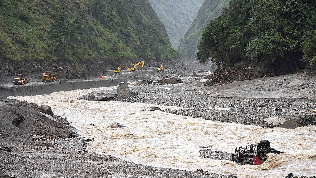
Authorities also halted movement along several major roads as the flood travelled south through the Bhotekoshi and Trishuli river systems.
But communities closest to the border had very little time.
“The flood crossed into Nepal around 8:40am and reached Syabrubesi within 10 minutes,” hydrologist Sauhard Joshi told Nepal News.
“If we had been informed while the flood was building up in Tibet, human casualties could have been significantly minimised.”
The problem, therefore, was not simply whether Nepal could send an alert. It was when authorities first knew an alert was needed.
What Happened to Nepal’s Monitoring Stations?
Some were themselves destroyed by the flood.
Nepal News, citing the Flood Forecasting Division’s preliminary technical report, said automated data feeds from monitoring stations at Bhotekoshi and Syabrubesi abruptly stopped after 8:40am.
Parajuli said four monitoring stations — at Rasuwa Bhotekoshi, Syabrubesi, Betrawati in Nuwakot and Malekhu in Dhading — were eventually swept away.
That meant parts of the network designed to measure the flood became casualties of the disaster itself.
The stations were useful for tracking what happened once water entered monitored stretches of river, but they could not provide meaningful advance warning of a sudden event beginning much farther upstream.
Experts writing in The Kathmandu Post said this exposed a central weakness in Himalayan early-warning systems: they are often better at detecting a flood after it reaches a monitored river than at identifying the mountain hazard that creates it.
“By the time a downstream gauge records a catastrophic rise, the most valuable warning time may already have passed,” water-security specialists Yadu Pokhrel and Saugat Aryal wrote.
Why Was This Flood Particularly Difficult to Predict?
Because it did not begin like a conventional monsoon flood.
There was no extreme rainfall in Rasuwa immediately preceding a flood of this magnitude, according to Nepali meteorologists.
Evidence instead points to a sudden collapse high in the Himalayan catchment, which sent ice, rock and debris plunging towards the river system.
Experts are still investigating the exact sequence, but preliminary assessments suggest the material may have temporarily blocked the Lhende Khola before accumulated water and debris surged downstream.
Such an event can unfold with extraordinary speed.
Unlike heavy rain, which can often be tracked hours in advance, a glacier or mountain slope can fail suddenly in a remote region where there are few instruments and no nearby communities to raise an immediate alarm.
That gives downstream authorities far less warning time.
Didn’t Nepal Issue Flood Warnings Beforehand?
It did, but they were not warnings for this particular disaster.
Nepal’s hydrology department had issued routine monsoon advisories warning of possible rises in small rivers and localised flash flooding in Rasuwa and Nuwakot.
Those notices later prompted claims that authorities had known a major flood was coming but failed to act.
Hydrologist Joshi rejected that interpretation.
He told Nepal News the earlier notices concerned conventional monsoon risks and could not have predicted the sudden catastrophic surge through Rasuwagadhi.
Predicting the precise time of a glacier collapse or major ice-rock avalanche remains extremely difficult.
The more realistic goal, experts say, is to detect such an event as quickly as possible once it begins and get the warning downstream before the flood arrives.
Could Seismic Monitoring Help?
Potentially.
The glacier collapse was powerful enough to generate a seismic signal, initially interpreted as an earthquake.
That presents both a problem and an opportunity.
A seismic network may detect a huge collapse almost immediately, but authorities need to determine quickly whether the signal represents an earthquake, landslide, avalanche or another type of event, and whether it threatens a river valley downstream.
Pokhrel and Aryal argue that Himalayan warning systems need to combine seismic observations with upstream river monitoring and satellite information so an unusual mountain event can trigger rapid verification and precautionary alerts.
For settlements closest to the source, even that may provide only minutes.
But farther downstream, those minutes could save lives.
Was Cross-Border Communication Part of the Problem?
Nepali hydrologists say it was.
The flood originated in a transboundary Himalayan river system, meaning events high upstream can reach Nepal before monitoring stations inside the country have enough time to provide an effective warning.
Nepal News reported that a similar flood devastated the Rasuwagadhi area last year, after which Nepal and China agreed to develop a mechanism for sharing water-related risk information along their border.
But Nepali authorities said they received no advance notification before Wednesday’s surge.
China’s embassy in Kathmandu has pushed back against suggestions that Chinese authorities knowingly failed to warn Nepal, saying casualties occurred on the Chinese side as well and that authorities there were also unaware of the impending disaster.
The available evidence therefore does not establish that China possessed an actionable warning and withheld it.
But the disaster has renewed calls for a system capable of transferring information automatically and immediately when unusual river flows, landslides, glacial instability or natural dams are detected upstream.
Could a Better System Have Prevented the Disaster?
Not the flood itself.
And experts caution that no warning network can reliably predict exactly when every glacier, slope or natural dam will fail.
But earlier information could have increased the time available to evacuate communities downstream.
The distinction is important.
The apparent failure was not that authorities ignored a precise prediction of Wednesday’s disaster. There is no evidence such a prediction existed.
Rather, the catastrophe showed how little time Nepal has when a sudden high-mountain hazard begins upstream and information reaches authorities only after the resulting flood has crossed the border.
Nepal can track rivers and send alerts.
The challenge exposed by the Bhotekoshi disaster is making sure the warning begins before the flood reaches those rivers and travels downstream faster than the water itself.