Home
+

Published : 23 Sep 2024, 02:12 AM
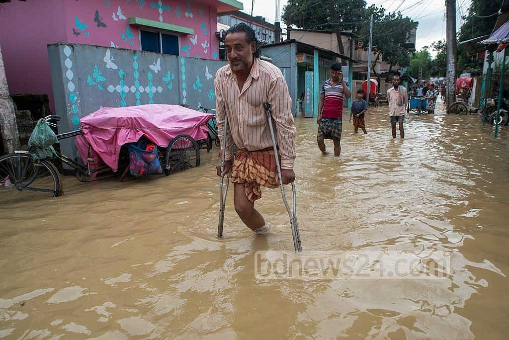
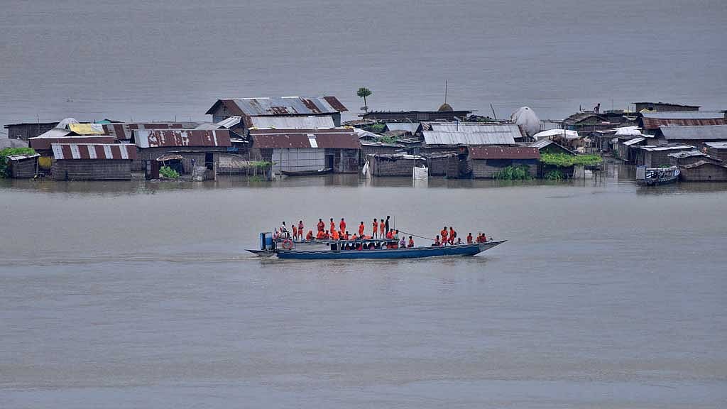
About a month ago, the northeastern region of Bangladesh was stunned by a catastrophic flood, and now a team of researchers from BUET's Water and Flood Management Institute has traced the disaster to an unusual suspect — a “flying river”.
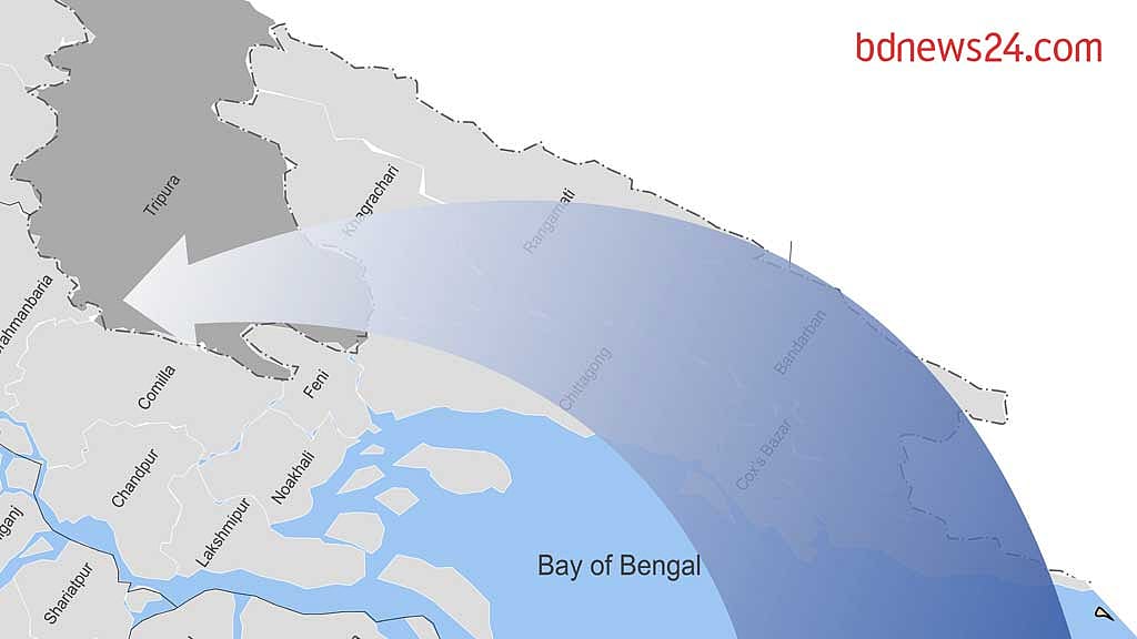
According to their findings, on Aug 18, an immense 'flying river' formed, stretching invisibly across the sky. Originating from the Bay of Bengal, it swept over Tripura and surged northward. This atmospheric behemoth spanned more than 2,000 kilometres in length and 500 kilometres in width, making it a formidable force that eluded the naked eye.
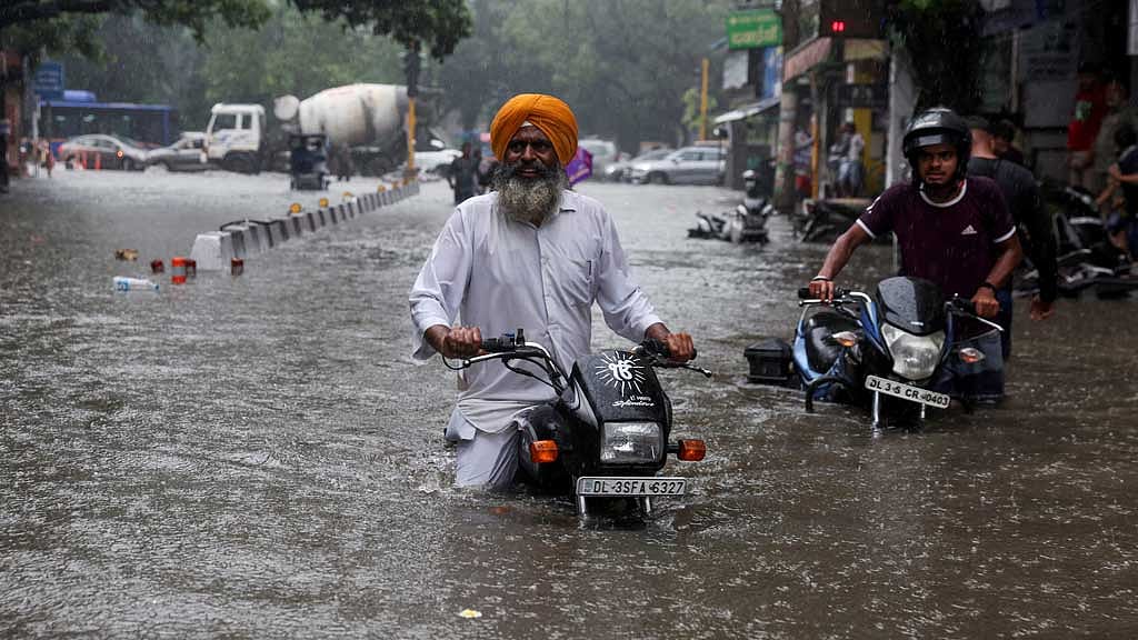
Due to upstream mountain runoff and extremely heavy rainfall, a massive flood from Aug 20 swamped vast swathes of areas, including Feni, Cumilla, and Noakhali. As homes were submerged within a short time, some of the affected people remarked that they had never seen such a horrifying flood in their lifetime.
A group of researchers from BUET’s Institute of Water and Flood Management, led by Associate Professor Shampa - who uses a single name - investigated whether the ‘flying river’ had a role in the floods.
Speaking to bdnews24.com, she said: "The flying river is one of the main reasons for this extremely heavy rainfall. The heavy rainfall is what led to the flooding in the northeast."
"There might be other phenomena at work here, but the presence of the flying river significantly intensified the flooding."
Typically, if rainfall exceeds 88 millimetres within 24 hours, it is classified as extremely heavy rainfall.
Explaining the concept of a flying river, Shampa said when such a river forms, it causes extremely heavy rainfall in a single day.
"For instance, if the normal rainfall in an area for the month of June is 100 millimetres, the formation of a 'flying river' can result in 300-400 mm of rain in just one day."
When asked why this river forms in the sky, Shampa explained: "It could be due to local convection cells, the development of a deep low-pressure system, or it could form beside such a system."
"A cyclone could also trigger the formation of a flying river due to the atmospheric flow, but it’s difficult to pinpoint the exact cause."
A flying river exacerbates the risk of massive floods in a short period, she said. "Since there is an unusually high amount of rainfall in a short time, there's less time to prepare. Therefore, we need to improve the entire flood management system. Timely warnings must be issued, and information about available shelters should be provided."
"First and foremost, we need to improve our ability to quickly identify such phenomena. We should also map out areas that have been previously affected by flying rivers."
HOW THE ‘FLYING RIVER’ WAS DETECTED
When flash floods occurred in the northeastern part of Bangladesh, the release of water from the Dumbur Dam in Tripura was blamed, triggering protests at several universities in Bangladesh.
Flying River
Due to global warming, the amount of water vapour or humidity in the air is steadily increasing.
According to scientists cited by the BBC, water evaporating from warm oceans is accumulating in the atmosphere like an invisible ribbon. This “atmospheric river” or “flying river” later descends as rain or snow, contributing to floods or severe snowstorms.
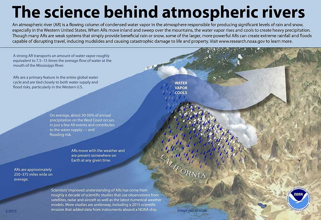
Each atmospheric river can be about 2,000 kilometres long, 500 kilometres wide, and approximately 3 kilometres deep. These rivers are becoming wider and longer, with some cases showing rivers over 5,000 kilometres in length. However, they are invisible to the naked eye.
Brian Kahn, an atmospheric researcher at NASA’s Jet Propulsion Laboratory, says: "They can be seen using infrared and microwave frequencies. That's why satellites are an effective tool for monitoring water vapour and atmospheric rivers across the globe."
In response, India's Ministry of External Affairs said: "Since 21th of Ausust, there has been widespread rainfall across Tripura and the adjacent districts of Bangladesh. Due to heavy inflows, water has naturally spilled out of the Dambur Dam."
At that time, the Indian Meteorological Department reported extremely heavy rainfall in Tripura. On Aug 20, the Sabroom region of Tripura recorded 375.8 mm, of rain in a single day.
During the first 21 days of August, the region was expected to receive 214 mm of rainfall; however, it experienced 538.7 mm, which is 151 percent more than normal.

HOW DID EXPERTS LINK THIS EXTREME RAINFALL TO THE FLYING RIVER?
Researchers from Bangladesh University of Engineering and Technology, or BUET, explained that in order to identify a flying river, they measure Integrated Water Vapour Transport, or IVT, which shows the amount of water vapour flowing in the atmosphere.
They gathered this data from the European Centre for Medium-Range Weather Forecasts, or ECMWF, an independent intergovernmental organisation of 35 countries that has been providing daily weather data since 1940.
Shampa explained, "There’s a dataset called ERA5. They use some measured data, but they primarily rely on satellite information. They upload daily data."
On Aug 18, a ‘flying river’ was present, stretching from the Bay of Bengal, passing over Bangladesh and Tripura, and moving further north. "We identified the flying river by analysing the data from ECMWF," she added.
NOT THE FIRST SKY RIVER IN BANGLADESH
Due to the lack of significant research on the 'flying river' in Bangladesh, it is difficult to determine how many past catastrophic floods were influenced by it.
However, by analysing the recent flash floods in the Sylhet region, Shampa found that from 2000 to 2023, there were 21 instances of extremely heavy rainfall in the region, and 17 of these were associated with a flying river.
Ahmed Hossain, a research scientist at the Center for Resilience and Youth, conducted his postgraduate thesis on 'atmospheric rivers' at BUET’s Institute of Water and Flood Management. His research focused on the Sylhet and Sunamganj regions.
Speaking to bdnews24.com, he said: “While working on another project, I realised that understanding the rainfall from the Meghalaya side is crucial for understanding Bangladesh's floods.”
During his research, Hossain discovered that extensive work had been done on flying rivers in the West, and considerable research exists in East Asia as well. In recent years, India has also started focusing on this phenomenon.
“We then tried to establish whether atmospheric rivers exist in Bangladesh. It turns out that the reason for the heavy rainfall in Cherrapunji is due to the formation of flying rivers. This excessive rainfall often causes sudden flash floods in Bangladesh, especially in the Sunamganj region, where the water level can rise dramatically in 10 hours or a day,” Hossain explained.
The residents of Sylhet faced their worst flood since 2004 in mid-2022, and BUET professor Shampa said a ‘flying river’ played a role in the disasater.
According to her, flying rivers typically form during the monsoon season in Bangladesh. However, some flying rivers can form just before or after the monsoon season.
When asked about the role of climate change in the creation of these sky rivers, Shampa said: "Research is still ongoing."
"However, due to climate change, instances of heavy rainfall are increasing. It’s possible that the likelihood of flying rivers forming is also rising, though this is not confirmed yet. Nonetheless, there is little discussion in the country about this new weather phenomenon."
Explaining how the flying river works, Shampa said: “During the monsoon season, a significant amount of water vapour moves northward from the sea. When it encounters obstacles like the Himalayas or other mountains, it triggers rainfall. A flying river forms in the sky, carrying vast amounts of water vapour.
"The volume of water in a flying river can surpass that carried by major rivers like the Amazon, Brahmaputra, or Jamuna. Due to its ability to transport such a large amount of water vapour, we call it a river. It is long and narrow."
‘FLYING RIVERS’ AROUND THE WORLD
Like Bangladesh, India has also been facing devastating floods this year. Hundreds of people have lost their lives, and a vast number have been displaced in several states.
Indian meteorologists believe that due to warming in the Indian Ocean, flying rivers are forming, which are influencing monsoon rainfall from June to September.
A 2023 study published in the scientific journal Nature revealed that between 1951 and 2020, India witnessed 574 atmospheric rivers during the monsoon season. The frequency of such extreme weather events has been increasing over time.
In India, nearly 80 percent of the most intense atmospheric rivers over the past two decades have resulted in flooding.
A team of scientists from the Indian Institute of Technology, or IIT, and the University of California was involved in this research. They found that between 1985 and 2020, seven out of the 10 deadliest monsoon floods in India were linked to atmospheric rivers.
According to the BBC, atmospheric rivers carry about 90 percent of the total water vapour floating in the earth’s atmosphere. The amount of water vapour in these rivers is nearly twice the normal flow of the world's largest river - the Amazon.
In April 2023, after severe thunderstorms, hailstorms, and rare rainfall, Iraq, Iran, Kuwait, and Jordan experienced catastrophic flooding. Later, meteorologists discovered that the air in this region contained a record amount of moisture. A similar event occurred in 2005, but with less moisture at that time.
Scientists say as the earth continues to warm rapidly, these atmospheric rivers are becoming longer, wider, and more intense, putting millions of people worldwide at greater risk of flooding.
A 2021 study published by the American Geophysical Union, an international, nonprofit scientific association, found that 80 percent of the heavy rains that fall during the early monsoon season – from Marchto April – in East China, Korea, and western Japan are associated with atmospheric rivers.
Sara M Vallejo-Bernal, a doctoral researcher at Potsdam Institute for Climate Impact Research in Germany, said the intensity of atmospheric rivers has increased significantly in East Asia since 1940.
“We have observed that since then, these rivers have become more intense in Madagascar, Australia, and Japan,” she said.

HOW PREPARED IS BANGLADESH?
In the course of her research, Shampa discovered a lack of studies on flying rivers in Bangladesh. “Since the monsoon here is very active, it’s difficult to distinguish between the effects of low-pressure systems, cyclones, and flying rivers. It is often assumed that the heavy rainfall is due to cyclones, but in reality, it could be the result of flying rivers."
“For instance,” she explained, “a cyclone may hit Odisha, and during the same time, it rains in Bangladesh. But in reality, the rain in Bangladesh is due to a flying river. Such phenomena have been observed.”
The recent floods in the northeastern Bangladesh have claimed at least 74 lives and affected over five million people. In Feni, Cumilla, and Noakhali alone, 56,349 cattle, buffalo, goats, and sheep perished.
Shampa believes that if the presence of flying rivers were included in weather forecasts, it could help significantly reduce such losses. “In Bangladesh, heavy rain usually follows the formation of a flying river by one or two days, and sometimes on the same day.”
She suggested that the Bangladesh Meteorological Department, or BMD, monitor the Bay of Bengal and the Himalayan regions to identify whether a flying river is forming and track its movement. “If we can alert people early, we may be able to reduce the damage to some extent. This information is crucial for managing flood damage here.”
Shampa emphasised that work should begin now to include flying river data in weather and flood forecasts.
She said, “In reality, it has become essential to include flying river data in forecasts. When a flying river forms in the Bay of Bengal and brings water vapour to Sylhet or elsewhere, if we can identify it when it forms, we could raise awareness.”
When approached on this issue, Executive Engineer of the Flood Forecasting and Warning Centre Sardar Uday Raihan told bdnews24.com: “Our target is to forecast floods. We will work jointly with the Meteorological Department to improve flood forecasts by identifying which systems cause flash floods and heavy rainfall.
However, meteorologist Bazlur Rashid from the BMD believes incorporating flying rivers into forecasts is quite challenging.
“Flying rivers cause widespread rainfall. But here, rainfall occurs over a small area, such as Feni and its surroundings. Was it raining in Dhaka when it was raining in Feni? When there’s heavy rainfall in a specific location, it’s not accurate to say it was caused by a flying river. If we apply weather models used in colder regions to our climate, they won’t work.”
When asked, Disaster Management and Relief Advisor Faruk E Azam told bdnews24.com, “I was not aware of (flying river). This is the first time I have heard of it from you. I will look into it and then take steps to work on it.”